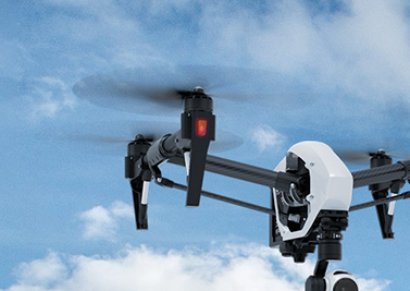

"Over-the-hill" real-time visual intelligence
Our UAS-50 is a mature, advanced, combat-proven, extended performance electric mini-UAS, optimized to provide covert, extended range real-time visual intelligence. The UAS is unique in its abilitity to fly even in strong winds and on cloudy or rainy days, assuring high operational availability for 3-4 hours and a communication range up to 50 km (optionally extendable to 80 km).
BATS' UAS-50 system provides Intelligence, Target Acquisition and Reconnaissance (ISTAR) capabilities.
The system is capable of operating in segregated airspace, following segregation procedures with manned aircraft. The system will manage the traffic information transmutation with the Mission ATC tower with a radio communication on radio frequencies.
Fully autonomous, from its point of launch to its accurate parachute and airbag recovery, the system delivers autonomous ease of use and high reliability, providing a very versatile and stable ISR platform.
Combining a stabilized CCD and IR payloads with proprietary ground exploitation software, the UAS allows for GPS-marked imagery to be relayed in real-time to the ground station. It presents an ultimate solution for supporting real-time video missions for open area as well as urban scenarios for military, peace keeping, low intensity conflict, security, law enforcement, S&R, disaster management and commercial applications.
Features
FEATURES
| Endurance | Unprecedented endurance for mini UAVs of up to 3-4 hours mission time |
| Extended control range | Based on its unique communication technology, the system achieves up to 50 km (extendable) with digital link, advanced video compression and tracking antenna |
| High performance optional payloads | Dual day/night and IR cameras gimbaled and stabilized payloads and/or optional high resolution gimbaled and stabilized photogrammatic payload |
| High resolution Video Transmission | The UAS can be optionally integrated with HD-ready day payload and can transmit HD-ready video (720px) to the ground, in order to provide better situational awareness and better detection, recognition and identification capabilities. |
| Immediate intelligence | The video image from the UAV is relayed to GCS in extremely low latency. The video is recorded with all intelligence information overlaid on the video (GPS coordinated of the target, etc.) |
| Severe weather operation | Supporting missions in severe weather in strong winds and rain of up to 10 mm/h |
| Ease of operation | Quick development and fast operational readiness, no need for prepared area, Launch and recovery in any terrain. |
| Small logistic and operational footprint | Small size and small crew (2 people), only one operator is required while the UAS is airborne |
Applications
APPLICATIONS
- Monitoring of designated areas or location of interest
- Continous tracking and monitoring of static and moving targets in open and urban environments including vehicles and humans
- Forward observer for firing units and BDA assessment post firing
- Disaster control and management operations (first responders)
- Search and rescue
- Forward situation awareness and operation command and control capabilities to the HQ
- Maritime Surveillance
- Force protection
- Security operations
- Law enforcement
- Optional Mapping on Demand (photogrammetric) missions
- Loitering around a given point / automatic holding
System Operation
SYSTEM OPERATION
| Operation | Description |
| Plan |
Mission planning can be done in 3 ways:
|
| Deploy/Launch |
Deploy/launch is done in 3 ways:
|
| Mission execution |
Mission execution is performed as follows:
|
| Recover |
Recovery of the UAV works as follows:
|
Specifications
SPECIFICATIONS
| Wing Span | about 3 m |
| Power plant | Electric brushless motor |
| Endurance | Typically, up to 4 hours depending on altitude ASL, weather and mission profile |
| Payloads |
Gimbaled and stabilized surveillance payload:
|
| Control Range | Video: up to 50 km (optionally extendable to 80 km) |
| Main communication link | 2.4-2.5 GHz spread spectrum Data Link |
| Video downlink | L-band COFDM technology |
| Navigation | The UAS has GNSS for horizontal and vertical position fixing and is capable of autonomous waypoint navigation with manual correction or over-ride for pre/in-flight reprogramming, during a signal loss and auto-homing |
| Video output | Real-time full motion video in common standard video file format (e.g. H264/MPEG-4 AVC) to be displayed in the Operations Center and/or other locations chosen by the mission |
| Video recording storing retrieve |
All videos transmitted to GCS and to the Command Center is recorded. The system supports 7 days of subsequent retrieval. FMV has to be stored in standard video file format (i.e. MPEG) including all relevant metadata, notably time, date, and geo-location of the sensor footprint/pin point. This capability includes a measuring tool capable of determining distance on the video screen. |
Price
PRICE
Please contact us and we will be pleased to discuss your specific requirements and provide you with a tailored offer.
Picture for UAS-50 at this page for illustration only.